Naive Mapping API
This page documents the public, user-facing classes for direct conversion of common input formats into RDF/N-Triples. These converters follow the same high-level pattern:
converter = SomeConverter(input_file, out_file)
converter.parse(...)
converter.export()
CSVConverter source
class CSVConverter(
    input_file,
    out_file,
    delimeter=",",
    ontology_uri="https://example.org/ontology/",
    resource_uri="https://example.org/resource/",
)
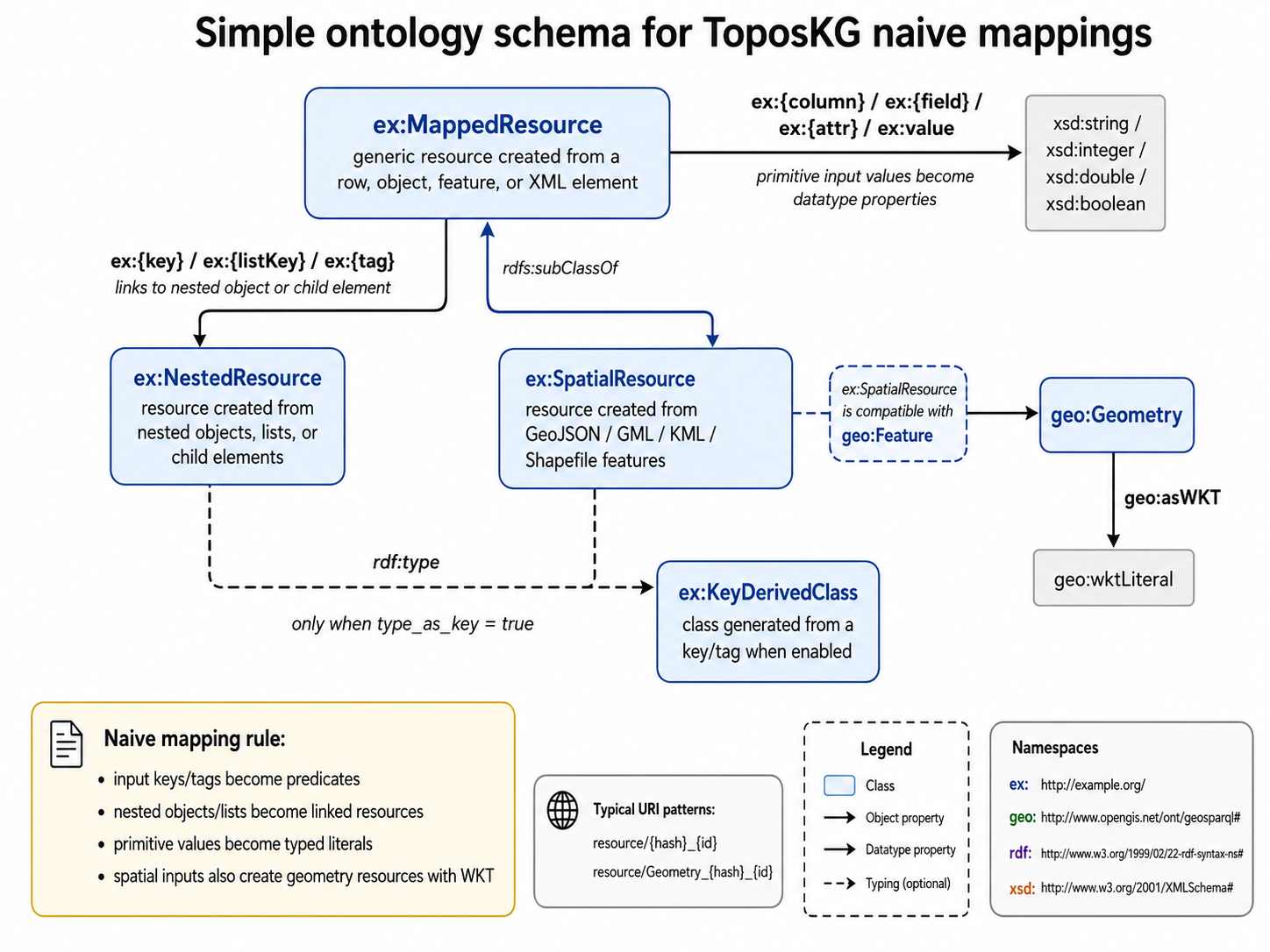
Naively converts a CSV file into RDF triples. Each row becomes an entity, and each CSV column becomes a predicate under ontology_uri.
Parameters
Parameter |
Type |
Default |
Description |
|---|---|---|---|
|
|
required |
Path to the input CSV file. |
|
|
required |
Path where the generated N-Triples file will be written. |
|
|
|
CSV delimiter used by |
|
|
|
URI prefix used to construct predicates from CSV column names. |
|
|
|
URI prefix used to construct generated subject URIs. |
Methods
CSVConverter.parse(id_columns=[], type_as_key=False) source
parse(id_columns=[], type_as_key=False)
Parse the CSV file and populate self.triples.
Parameter |
Type |
Default |
Description |
|---|---|---|---|
|
|
|
Ordered list of CSV columns to use as row identifiers. The first available value is used. If no value is found, an incremental ID is generated. |
|
|
|
Accepted by the public signature for consistency with other converters. It is currently not used by |
CSVConverter.export() source
export()
Write the parsed triples to out_file in N-Triples-like syntax.
Example
from toposkg.converter.toposkg_lib_csv_converter import CSVConverter

converter = CSVConverter(
    input_file="data/places.csv",
    out_file="out/places.nt",
    ontology_uri="https://example.org/ontology/",
    resource_uri="https://example.org/resource/",
)
converter.parse(id_columns=["id"])
converter.export()
JSONConverter source
class JSONConverter(
    input_file,
    out_file,
    ontology_uri="https://example.org/ontology/",
    resource_uri="https://example.org/resource/",
)
Naively converts JSON documents into RDF triples by recursively walking dictionaries and lists. Nested JSON objects can become linked resources, while literal values become typed RDF literals.
Parameters
Parameter |
Type |
Default |
Description |
|---|---|---|---|
|
|
required |
Path to the input JSON file. |
|
|
required |
Path where the generated N-Triples file will be written. |
|
|
|
URI prefix used to construct predicates and optional classes from JSON keys. |
|
|
|
URI prefix used to construct generated subject URIs. |
Methods
JSONConverter.parse(id_fields=[], type_as_key=False) source
parse(id_fields=[], type_as_key=False)
Parse the JSON file and populate self.triples.
Parameter |
Type |
Default |
Description |
|---|---|---|---|
|
|
|
Ordered list of JSON keys to use as identifiers for generated resources. If no key is found, an incremental ID is generated. |
|
|
|
If |
JSONConverter.export() source
export()
Write the parsed triples to out_file.
Example
from toposkg.converter.toposkg_lib_json_converter import JSONConverter

converter = JSONConverter("data/places.json", "out/places.nt")
converter.parse(id_fields=["id"], type_as_key=True)
converter.export()
GeoJSONConverter source
class GeoJSONConverter(
    input_file,
    out_file,
    ontology_uri="https://example.org/ontology/",
    resource_uri="https://example.org/resource/",
)
Converts GeoJSON features into RDF triples. Feature properties are converted like JSON fields, and geometries are serialized as GeoSPARQL geo:asWKT literals connected through geo:hasGeometry.
Parameters
Parameter |
Type |
Default |
Description |
|---|---|---|---|
|
|
required |
Path to the input GeoJSON file. |
|
|
required |
Path where the generated N-Triples file will be written. |
|
|
|
URI prefix used to construct predicates from GeoJSON property names. |
|
|
|
URI prefix used to construct feature and geometry URIs. |
Methods
GeoJSONConverter.parse(id_fields=[], type_as_key=False) source
parse(id_fields=[], type_as_key=False)
Parse all features in the GeoJSON file, create feature entities, add geometry triples, and populate self.triples.
Parameter |
Type |
Default |
Description |
|---|---|---|---|
|
|
|
Ordered list of property keys to use as feature identifiers. If none is found, an incremental ID is generated. |
|
|
|
Accepted by the public signature. The converter stores the flag internally for nested dictionary handling. |
GeoJSONConverter.export() source
export()
Write the parsed feature, property, and geometry triples to out_file.
Example
from toposkg.converter.toposkg_lib_geojson_converter import GeoJSONConverter

converter = GeoJSONConverter("data/pois.geojson", "out/pois.nt")
converter.parse(id_fields=["osm_id"])
converter.export()
XMLConverter source
class XMLConverter(
    input_file,
    out_file,
    ontology_uri="https://example.org/ontology/",
    resource_uri="https://example.org/resource/",
)
Naively converts XML trees into RDF triples. XML elements become generated resources, attributes become predicates, and element text becomes a value literal.
Parameters
Parameter |
Type |
Default |
Description |
|---|---|---|---|
|
|
required |
Path to the input XML file. |
|
|
required |
Path where the generated N-Triples file will be written. |
|
|
|
URI prefix used to construct predicates and optional classes from XML element/attribute names. |
|
|
|
URI prefix used to construct generated XML element resources. |
Methods
XMLConverter.parse(id_fields=[], type_as_key=False) source
parse(id_fields=[], type_as_key=False)
Parse the XML tree recursively and populate self.triples.
Parameter |
Type |
Default |
Description |
|---|---|---|---|
|
|
|
Ordered list of XML attributes to use as element identifiers. If none is found, an incremental ID is generated. |
|
|
|
If |
XMLConverter.export() source
export()
Write the parsed XML triples to out_file.
Example
from toposkg.converter.toposkg_lib_xml_converter import XMLConverter

converter = XMLConverter("data/places.xml", "out/places.nt")
converter.parse(id_fields=["id"], type_as_key=True)
converter.export()
ShapefileConverter source
class ShapefileConverter(
    input_file,
    out_file,
    ontology_uri="https://example.org/ontology/",
    resource_uri="https://example.org/resource/",
)
Converts an ESRI Shapefile to RDF by first converting it to a temporary GeoJSON file with GeoPandas, then delegating RDF generation to GeoJSONConverter.
Parameters
Parameter |
Type |
Default |
Description |
|---|---|---|---|
|
|
required |
Path to the input |
|
|
required |
Path where the generated N-Triples file will be written. |
|
|
|
URI prefix used to construct predicates from feature attributes. |
|
|
|
URI prefix used to construct generated feature and geometry URIs. |
Methods
ShapefileConverter.parse(id_fields=[], type_as_key=False) source
parse(id_fields=[], type_as_key=False)
Read the Shapefile, convert it to temporary GeoJSON, and populate self.triples through GeoJSONConverter.
Parameter |
Type |
Default |
Description |
|---|---|---|---|
|
|
|
Ordered list of attribute names to use as feature identifiers. |
|
|
|
Forwarded to |
ShapefileConverter.export() source
export()
Write the parsed triples to out_file.
GMLConverter source
class GMLConverter(
    input_file,
    out_file,
    ontology_uri="https://example.org/ontology/",
    resource_uri="https://example.org/resource/",
)
Converts GML to RDF by first converting it to a temporary GeoJSON file with GeoPandas, then delegating RDF generation to GeoJSONConverter.
Parameters
Parameter |
Type |
Default |
Description |
|---|---|---|---|
|
|
required |
Path to the input GML file. |
|
|
required |
Path where the generated N-Triples file will be written. |
|
|
|
URI prefix used to construct predicates from feature attributes. |
|
|
|
URI prefix used to construct generated feature and geometry URIs. |
Methods
GMLConverter.parse(id_fields=[], type_as_key=False) source
parse(id_fields=[], type_as_key=False)
Read the GML file, convert it to temporary GeoJSON, and populate self.triples through GeoJSONConverter.
Parameter |
Type |
Default |
Description |
|---|---|---|---|
|
|
|
Ordered list of feature attributes to use as identifiers. |
|
|
|
Forwarded to |
GMLConverter.export() source
export()
Write the parsed triples to out_file.
KMLConverter source
class KMLConverter(
    input_file,
    out_file,
    ontology_uri="https://example.org/ontology/",
    resource_uri="https://example.org/resource/",
)
Converts KML to RDF by reading all KML layers with Fiona/GeoPandas, merging them into a temporary GeoJSON file, then delegating RDF generation to GeoJSONConverter.
Parameters
Parameter |
Type |
Default |
Description |
|---|---|---|---|
|
|
required |
Path to the input KML file. |
|
|
required |
Path where the generated N-Triples file will be written. |
|
|
|
URI prefix used to construct predicates from feature attributes. |
|
|
|
URI prefix used to construct generated feature and geometry URIs. |
Methods
KMLConverter.parse(id_fields=[], type_as_key=False) source
parse(id_fields=[], type_as_key=False)
Read all layers in the KML file, convert them to temporary GeoJSON, and populate self.triples through GeoJSONConverter.
Parameter |
Type |
Default |
Description |
|---|---|---|---|
|
|
|
Ordered list of feature attributes to use as identifiers. |
|
|
|
Forwarded to |
KMLConverter.export() source
export()
Write the parsed triples to out_file.
Example for spatial file converters
from toposkg.converter.toposkg_lib_shapefile_converter import ShapefileConverter

converter = ShapefileConverter("data/admin_units.shp", "out/admin_units.nt")
converter.parse(id_fields=["ADM_ID"])
converter.export()